Wigwam Dome

August 29, 2020
Wigwam Dome
Trail of Tears 5.8
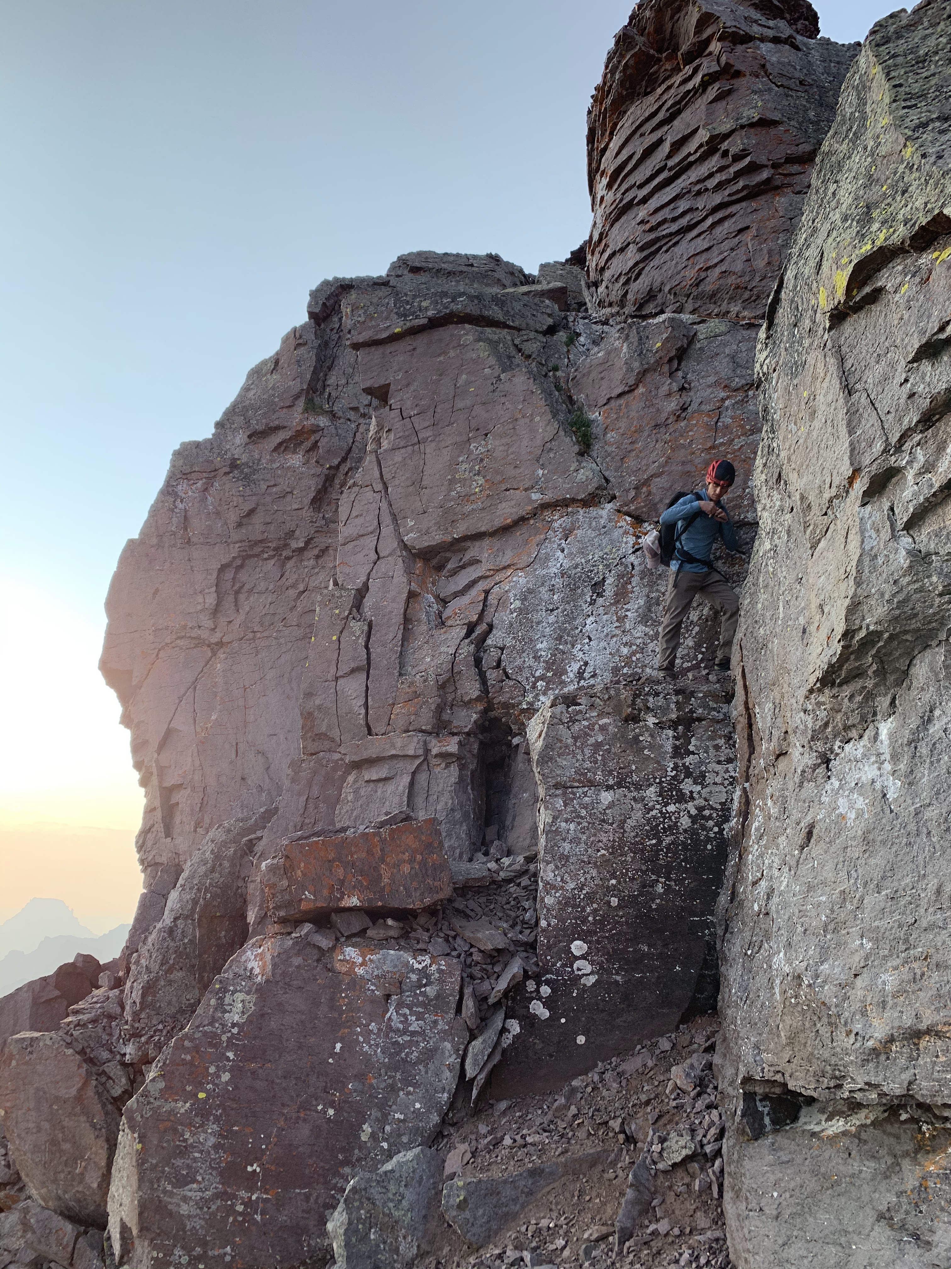
Rain was forecasted for the day but Laura and I figured we'd at least go take a look at a climb we have wanted to do for a while now. Knowing that it was well within our ability, we set off to race the rain. I loaded up the packs with a set of cams #.2-3 and doubles in #.5-2 along with slings, 1/2 set of stoppers and a 70 meter rope. The rack was plenty and I only used the #3 one time at a belay. Wigwam Dome is about 2 miles (1.4 to the turnoff) from the Wigwam Creek Trailhead in the Lost Creek Wilderness and holds a mix of excellent granite crack and slab climbs.

Trail of Tears is a 5 pitch climb. Pitch 1 is an easy 5.6 traverse with sparse protection that leads to a belay below a long right facing dihedral that you follow most of the way up the dome. The route description says to traverse to some cracks on your right at the top of pitch 3 rather than climbing the dihedral to its end but I did 2 pitches of climbing the dihedral without traversing over to the cracks on the right and felt the climbing was still 5.8+ and was a far better option than traversing the run out slab. As i was climbing the final 30 feet of the dihedral the thunder started and I knew we better hurry. we had two pitches left to climb and bailing would not have been easy as there are no bolted anchors on this climb. Laura raced up to meet me at the belay and I quickly set off on the very nice finger crack variation to my left. I took this all the way up to a nice cave and set another belay. As the sprinkles started, I climbed the 15 feet of 5.8 slab on the last pitch and then climbed as fast as I could to the summit of the dome. At the summit I ran around a large boulder to use the rope as a belay and screamed to Laura to begin climbing. As she climbed the final 100' the skies opened up on us. When she reached the top we took shelter under trees and packed our gear. The 5 pitches took us 1.5 hours and we are lucky to have moved at a fast pace today. It rained on us most of the way while we hiked off of the dome back to Laura's backpack at the base of the route. when we arrived, the entire route was a waterfall! We knew we had lucked out today as we snapped a few photos and made the short 2 mile hike back to the trailhead!


Teakettle Mountain and "Coffeepot"

 August 23, 2020

Teakettle Mountain - 13,819’

“Coffeepot” - 13,568


Teakettle Mountain and “Coffeepot” are both technical summits above 13,000’. Laura and I had just completed the 100th highest mountain in Colorado climbing Dallas Peak yesterday so on the same mission, we would go for Teakettle, which is 98th on the list. It’s only about 4 miles but is straight up a scree field much of the way. Pulling up to the trailhead in Yankee Boy Basin, we passed many cars and hikers since the same road accesses Mt. Sneffles, a 14,000’ peak. We knew there would be a lot of people but as soon as we set off on the path toward the peak just shy of the magic 14’000’, we only saw one other group all day. As we hiked up the initial scree gulley after leaving the car at 7:15am, we quickly realized this approach would be much like yesterday - scree filled and slippery talus hopping for 2,000’. We put our heads down and by 9 am we had reached the saddle to cross over toward Teakettle.

                  We decided that since “Coffeepot” was right there, we might as well grab the summit quickly so I went ahead and found an easy 5.3 scramble to the summit. Laura quickly followed and we were rappelling off shortly after at 9:30. We descended and traversed the loose slopes aiming for the black gulley that provides access to Teakettles upper slopes. Moving quickly we were able to reach the summit tower of the mountain in 30 minutes.

We spent some time goofing off in the handle of the teakettle and then traversed around to the east to find the chimney leading to the summit. I scrambled up the 5.3 chimney to the top and Laura quickly followed. While we were down taking pictures, Laura had eyed a great corner system with a set of hand and finger sized cracks in opposing sides. It looked amazing and probably went at about 5.7. Because I had no gear and only a single 8mm rope and no climbing shoes, leading the pitch was not possible. Laura and I decided that we would set up a top rope scenario off the summit and I would lower off and climb the 50’ pitch in my tennis shoes. We are not sure if anyone had done this variation before, but it was definitely worth it. Great fun with perfect hands on the left and fingers on the right. Most of the footholds would break off when I attempted to weight them so I figure I am only one of a few, if any, to have climbed this line to the summit of Teakettle Mountain.


It was now almost 11 am and we had goofed off long enough. We set up a rappel with our 40 meter rope, which was plenty long enough to get off both summits, and returned to the talus filled slopes we would descend back to our car. Wasting no time and scree skiing down toward the black gulley, we saw the only two people we would encounter all day. They were kind enough to move out of the line of rock fall and let us pass above and then below them before continuing on. As we exited the gulley, we would hear the rock avalanches that were caused by the other climbers. We were fortunate that this is not a popular mountain because it would be terribly dangerous with rockfall. Before long we were back at the saddle and descending the ridgelines back to the Jeep. We made a mistake at the very end when we should have been one ridge to the right. We went about 100 feet too far left and got cliffed out. We decided to downclimb sketchy terrain eventually reaching a grassy field but would have been far better off simply going back up to the proper descent. Back to the Jeep safely, we celebrated our safe summits for the day. It was 1 pm now and we needed to get back to our daughter, Hazel so we headed back to Ouray for an afternoon of relaxing and cooking dinner over a wood fired grill.


Dallas Peak

August 22, 2020

Dallas Peak 13,815’


While large wildfires engulf the northern and western portion of Colorado, Laura and I thought we might escape the smoke path by heading west but as luck would have it, smoke from the California wildfires was swirling around and through Colorado too. So a smoke filled weekend began with our 6 hour drive to Ouray, a beautiful mountain town in southwest Colorado. Making a stop at Ridgeway State Park to break up the drive, we checked off Hazel’s 18th state park in just 12 weeks of life and did a few short hikes while we were there. We continued onto Ouray and grabbed a small cabin for Laura, her mom (babysitter) and Hazel. I decided to sleep outside since the cabin was small so I blew up my air bed and crashed in the dirt around 9 pm anticipating a 1 am wakeup. Either a dog or a fox came by to visit that night but I was too tired to catch what it was before it scampered off when it startled me from my sleep.

Eating bagels and boiled eggs as we drove toward Telluride and the Mill Creek Trailhead, we arrived and set off quickly at 2:15 am. Laura set the pace on the great trail as we chatted to keep wildlife aware of us in the dark. We came across a herd of elk and a few deer, but nothing to be concerned about. After about 4 miles of steep trail, we cut off onto the grass covered talus slope and began the slip and slide that defines much of the remaining route to the summit of Colorado’s 100th highest mountain and the one the guidebook says is the most difficult. As we climbed, slipped, clawed and crawled our way up the south slopes of Dallas Peak, we eventually reached the gullies and what we hoped would be more solid ground. 
We were wrong - no solid ground around here! We worked our way east around the impressive pillars of the east face of the mountain and eventually toward the upper portions of the mountain above 13,000’. Route finding was relatively straightforward to this point but as we consulted the guidebook description for the final portion of the climb, we became confused. It is way overwritten with directions, elevations, gullies and navigation when it should simply say “locate the car size chockstone and climb the gully immediately to the right of it”. Laura and I wandered aimlessly for over an hour before finding the best path and access to the north side of the mountain. We quickly scrambled down a sloping ledge and ascended a dihedral system of scary loose rock that is about 5.3 in difficulty. We chose to solo rather than rope up as both of us are comfortable climbing in hiking shoes at this grade.


We were atop Dallas just before 7:30 am. The sunrise over Mt. Sneffles was spectacular due to the smoke but when we looked across the valleys to other mountains we have climbed, the smoke made for disappointing views. Laura made some milk for the kid while we had a snack on the summit. I set up the rappel on the recently installed cable with safe rappel rings and we began our descent at 8:05 am. I brought a 40 meter rope which turned out to be perfect length. Anything shorter would be too short. We did two rappels and got back on the path we had come up.


We were nervous about the descent thinking it would be dangerous with all the loose scree sitting on top of larger loose talus but we were fairly comfortable skiing down and hopping or down climbing facing in when the slopes called for clawing with your hands to keep from sliding down. As we passed back by the east face, we admired the potential climbing routes but figured the rock would be too poor quality to climb safely. As we continued down what we had ascended in the darkness of the night, I wondered why the heck anyone would go up this way when in fact it was the exact way we had come up! Seems ridiculous but I was happy to not know what we were going up in the darkness and how long you had to deal with the nastiness! We eventually made our way back to the good Mill Creek Trail and made quick work of the 4 remaining miles to the Jeep at 11:30 am. Roughly 11.5 miles and 5,600 feet of total elevation gain is what I recorded.


Lightning Pyramid - Thunder Pyramid - Pyramid Peak Traverse


August 8, 2020

Lightning Pyramid 13,722’ -> Thunder Pyramid 13,932’ -> Pyramid Peak 14,018’ Traverse

The Elk range is known for both its beauty and the loose, fragile, shale like rock that its mountains are composed of. These mountains would prove to be just that – beautiful and loose. Laura and I wanted to stand atop Thunder Pyramid since it is one of Colorado’s highest 100 peaks but we knew it would be a somewhat dangerous endeavor.
The mountain has claimed more than a single life and we did not want to be next. So, with the Maroon Lake trail head limiting parking and visitors this year, we figured it would be good to try the mountain hoping we would be the only ones up there. 
Turns out that was a good decision because we were the only ones on the mountains that day until we reached Pyramid. Isaac came up and climbed another 14er in the area so he dropped Laura and I off at the trail head at 5 am. We shouldered our light packs and off we went on the rocky trail that leads toward Crater Lake. Passing by the cairn that leads to Pyramid Peak and that would be our exit later that day, we made good time hiking along the mostly flat ground before reaching Crater Lake, the unmistakable bent tree and eventually crossing Maroon Creek and turning upward toward the tall pile of rocks we would climb that day.
Stopping for a break at 7 am, we discussed our plan to get to the scree gullies while I ate a peanut butter sandwich. Laura and I determined that we would climb around some small cliff bands and through a short section of trees to reach the upper portions of Len Shoemaker Basin and get closer to the gullies before choosing what route we would take to the ridge. We were efficient and didn’t get stuck in the trees for long before we reached a clearing and stopped to talk about the line we would ascend. We knew the standard route to Thunder Pyramid was to head up the obvious white gully but we decided to make a judgement call and head up the next gully to the South. The rock gully was partially filled with snow and looked as stable as the white gully from afar, but we were wrong. As we began ascending toward the snow in the gully we quickly figured out that we had made a mistake and should have traversed to the white gully. As we cautiously worked our way up, the mountain would move around us. One step and 20’ of rock would move below you. We decided to get out of the gully and work up bands of rotten rock that eventually lead us to the saddle of Lightning and Thunder Pyramid. 
The rock here was terrible and even testing every handhold and foothold wasn’t good enough as I pulled off large chunks while attempting to scramble the moderate terrain. 
I would guess it was mostly fourth class scrambling but included a few sections of 5.4 terrain. Laura and I knew we had made a big mistake and that we likely had cost ourselves and hour or two of time, but we also knew the safest way off was now up. We continued, climbing closely together and always trying to not have one of us below the other and reached the saddle around 9:15 am. We made the quick traverse over to Lightning Pyramid at 9:25 am and took a break for food and water. Looking through the summit register, there were only a few names, mostly ones I recognized or was friends with. It appeared that only a few people a year climb this mountain as the date on the bottom of the first page was 2018. 
The view of the Maroon Bells and the surrounding areas was amazing. This must be one of the best summit views in Colorado! Looking across the ridge, we knew we had a long way to go and a lot of loose rock ahead of us. The down climb off of Lightning was straight forward. We worked mostly along the top and sometimes on the east or climbers right side of the ridge as we scrambled toward Thunder Pyramid. As we neared Thunder, we ascended a gully that lead us to the top of the white gully on the other side of the ridge. From here the path seemed a bit more traveled as we found our way to the summit at 10:45 am. 
No time to waste here so we had a drink of water and began our climb down to the ridge connecting Thunder and Pyramid Peak. There is not a lot of information out there on this traverse, so we really didn’t know where to go except across. There were many ups and downs that we would navigate along the way. The down climb off of Thunder was 4th class with only a few low 5th class moves then we traversed maybe 100’ below the ridge on the east, or right side. We constantly discussed climbing the ridge proper but never really did. 
We would traverse the terrible loose rock upward and forward until we reached a point where we didn’t think that side would go any longer then we would find ourselves on the other side of the ridge crest. Crossing back and forth 4 or 5 times as we encountered difficulties along the way, we felt like our route finding was good and we chose a decent route that lead us to the final chimney leading to Pyramid Peak. 
As we ascended the class 5 chimney, we turned to our right and traversed the short distance over to the summit of Pyramid Peak where we saw the first person all day. 

It was 1 pm and we were supposed to meet Isaac at 2 so we got off the summit quickly. Both Laura and I had climbed Pyramid Peak several times so the route finding on the way down was easy for us. We descended through the green gully, across the traverse and step across and then around the corner to the saddle. As always, we passed some goats as we descended. 
The walk down the amphitheater was as terrible as I remembered and I hope that soon the Colorado Fourteeners Initiative will put some work in here since it sees a lot of traffic and is eroding badly. Down and through the boulder field we went and as we reached the trees and better trail we picked up speed and ran the remainder of the way out to the trail head. We were back safely at 3 pm. For as beautiful as the surroundings are, I would not recommend this climb to anyone unless it is done as a snow climb in the springtime. I was nervous before the climb and for good reason. It is dangerous and scary with some of the loosest, crumbly terrain I have ever encountered in the mountains. It is unprotectable and a rope would make the constant rockfall even worse. I was glad to have had Laura there with me on this one as she is always calm and makes good decisions and today all of that mattered.

“The Citadel” 13,294’ to Pettingell 13,553’ Traverse


July 31, 2020
“The Citadel” 13,294’ to Pettingell 13,553’
9.5 miles
5.5 hours car to car from Herman Gulch Trailhead

Laura and I had planned to climb a centennial peak – one of Colorado’s highest 100 mountains – but upon leaving our house in Colorado Springs we learned that the highway was closed due to police activity in the area. Headed west at 7 am we quickly reached the traffic jam from the closed road. While we were waiting in line to turn around, we spotted a bear on the roadside having a deer for breakfast. Humm, seems like this is going to be an interesting day.

As we turned around and headed back down the highway, we figured our best option would be to head north and find a fun mountain to climb somewhere on the front range. We chose to go for The Citadel to Pettingell Traverse having had it on our to do list for a while now. The traverse does have a short 5.4 section that most people rappel but since we were not planning to do a technical climb today we did not have a rope with us. We agreed that we were both comfortable down climbing 5.4 terrain and upon reaching the difficult section we would turn around if either of us felt uncomfortable for any reason. We reached Herman Gulch trailhead just after 9 am and were walking on the excellent trail toward Herman Lake at 9:30. The parking lot was overflowing with cars and the trail was busy with day hikers. We made good time on the approach to the lake, cutting off about ½ mile below the lake in an area we determined would be easy to cross over to access the saddle between Mount Bethel and The Citadel. Avoiding most of the willows and eventually connecting into a nice trail, we reached the saddle quickly and stopped for a short break.
We hiked up a faint path leading to the ledges and gullies that we would then climb to the summit of The Citadel, Laura calling out to me “don’t kick any rocks down on me”! I was extra careful as the gullies were loose in some areas. We reached the summit at 12:15 pm, snapped a few pictures, had a quick snack and took off across the traverse. Down climbing and moving swiftly, we had reached the major difficulty within 15 minutes. Laura found the rappel slings and assessed the terrain we would need to navigate without a rope. She climbed down about 20’ to a ledge where there was a slight overhang but stopped there. I came down to her and looked around for myself. 

We decided rather than down climbing where the rappel would drop you that we would move over about 15’ and work our way down a separate gulley. I made the awkward moves to get down the last 10’ and then guided Laura’s feet to good ledges as she down climbed the same section. The major difficulties were now past, so we picked up speed and scrambled our way to the summit of Pettingell by 1:30 pm. Just over an hour on the traverse felt good and we were both having a great time in the mountains! We chose to walk off the east ridge of Pettingell and cut down a large scree gulley to get back to the lake. Before we started the day, we wondered why nobody climbed Pettingell first and did the traverse in the opposite direction, but now we knew. Nobody in their right mind would walk up that scree gulley! Upon reaching the lake we once again met up with the day hikers. We stopped for some wildflower photos and did our best to jog down the good trail for the 3 miles back to the car. We finished at 3 pm and were very pleased with how the day went. The skies were sunny all day and we thoroughly enjoyed the interesting traverse.


Eureka Mountain

April 21, 2024 Eureka Mountain 13,505' Eureka Couloir Hoping to get some spring skiing in before the snow went away completely, I sugges...

Popular Posts