Sentinel Point

Sentinel Point
August 27, 2023

Sentinel Point, 12,527' is a sub point on the west side of Pikes Peak. It is essentially a large pile of rocks that sits above tree line but is a beautiful hike and has good summit views. After hiking 1,300 steps on the Manitou Incline just yesterday, Hazel was excited to get outside again and hopefully see some animals along the trail. I suggested we head to Sentinel Point as it is fun hiking through the meadow and I was hopeful that we would see some deer or other wildlife. I also thought Hazel could hike a good portion of the lower part and would enjoy the time with her parents. 

We enjoyed the hike and Hazel wore her alien glasses from Grandpa

When we arrived at the trailhead, Hazel asked to be carried in her backpack, and after some argument, I gave in and carried her up the first mile of steep trail from the trailhead. When we cutoff toward Horsethief park and the trail flattened out Hazel was happy to hike on her own. As Laura, Hazel and I hiked across the beautiful meadow, we looked across the valley and saw a coyote scampering just below the trees. Hazel was excited and kept on walking and looking for more animals. We soon encountered a worm on the trail. Blasting out with laughter, Hazel was excited to see more things and talked about how he was so cute! Hazel had walked almost 2 miles by this time and Laura and I were happy to have her hiking on her own as she is quite heavy to be carrying long distances any longer. 

Justin says Hazel didn't learn that from him (wiping her nose on her sleeve).  Also, this is the only picture I have of Hazel hiking on her own on this specific trip so I had to include it.

As the trail entered the forest and the terrain began to steepen, Hazel pushed on. She hiked a total of 4 miles and 1,000' of elevation gain. Laura and I were proud and again, perhaps easier this time, gave in to her requests to be carried in her backpack again. We were soon exiting tree line and making our way toward the rocky scramble and the summit of Sentinel Point. 

Views of Sentinel Point through the trees as we get closer

Great views of Pikes Peak and Devils Playground

Clouds built and rain was imminent as we summited and snapped a few happy photos. The three of us were soon headed down, but this time Hazel rode with Laura and I got to take it easy. 

High-Five Dad!

The summit is very blocky

We raced the rain and encountered a light rain after putting Hazel's rain jacket on exiting the forest once again nearing horsethief park. We successfully made it back to the trailhead and car totaling a round trip of 5 hours 10 minutes. Note to Hazel - when you're old enough and are reading this blog - we're counting this as a big summit for you since you did so awesome and we love you to the moon and back!


We were happy despite a little bit of rain.


Crestones Traverse

Crestones Traverse

August 19, 2023

Crestone Peak NW couloir + traverse to Crestone Needle

Dr. Knoche and I were talking about mountains after our weekly Thursday morning breakfast. He asked when we could get out again and I told him I thought he may be interested in joining us for the Crestone Traverse Laura and I had planned for the weekend. The three of us confirmed plans and met at our house at 4 am. With a goal of being walking by 6 am, I leaned into the skinny pedal and had us at the upper South Colony Lakes trailhead by 5:50. The three of us laced up shoes and were walking at 6:06 am. Not bad! 

Knowing we were in for a fairly long day, we hiked at a fast pace up the road to the kiosk and cutoff toward Humboldt Peak. Taking a short break for food and water, we were soon moving again and quickly reached the turn toward the Humboldt saddle and our intended route, the NW couloir on Crestone Peak. Laura and I knew the route well as we had just climbed it several months back while the couloir was still filled with snow. 

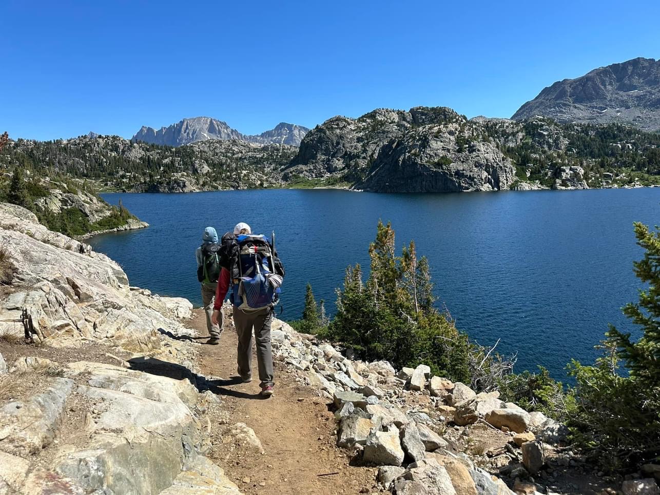
Justin, Randy and Indra making their way across the ridge with Humboldt in the background

As we approached the Humboldt saddle, I encountered a hiker looking at his phone map. Indra seemed to be off route and looking for direction. He took our willingness to help as an invitation to hike with us for the remainder of the day and so on we continued, slightly concerned about being responsible for someone else, but happy to be able to help him out. 

Laura, Randy and Indra making the way across the ridge to Bears Playground

As we reached the ridgeline, we scrambled across, making bears playground by 9:30. As we approached our intended route, we noticed someone coming across the flat area and catching us quickly. Wyatt had already climbed several peaks this day and was happy to see others heading to the Crestones as he was. He likely could have moved much faster than the pace the four of us were "cautiously" moving at but chose to stay close, likely enjoying the company after being out alone for a full day to this point. Now, as a group of five, we cut off shortly before reaching the saddle of the red gulley and climbed a fourth class line directly to the summit of Crestone Peak. 

Wyatt, Randy, Justin and Indra climbing the northwest gully with Kit Carson peak in the background


Randy and Wyatt in the final section before the summit of Crestone Peak

We relaxed, ate some food and were quickly descending toward the traverse entry point and heading toward Crestone Needle. We quickly found where to exit the red gully descent from Crestone Peak and step by step, made our way over three different shoulders of rock bands and closer to the needle. 

Randy, Indra and Justin descending the red gully before turning onto the traverse route

As we passed the halfway point of the traverse, we had two more hikers join our group. They had been off route on the traverse and were happy to have others to climb with and provide some route finding! Now...(as a group of seven!), we continued onward to the most difficult climbing of the day. 

Our group on the final stretch of the traverse before the headwall to the summit of Crestone Needle

We all easily climbed past the 5.2 bulge and across a short knife edge to finally reach the headwall that leads to the summit of Crestone Needle. The two hikers who had joined us most recently had friends who were on the mountain earlier that day and had left a rope. As it hung down from the summit, I led our group 15 feet to the right on easier terrain and scrambled quickly to the summit. 

Justin showing us the hard way to get over the bulge

Everyone finding their path up the final headwall of the Crestone traverse

Cheers! Fun times on the summit of Crestone Needle

Randy, myself, Indra and Wyatt enjoyed the summit and a sip of wine - Thanks Randy - while Laura helped to coil the rope with the other two climbers from the USAFA. A short celebration later, we decided it was time to descend. We made our way, stepping carefully down the gullies of Crestone Needle, eventually reaching a good trail to Broken Hand Pass. After descending the pass, we chose to go right at the Crestone Needle sign as Laura and I did in the snow several months back. We looked at the map after we returned home and it seems this way is quite a bit out of the way and likely takes much longer than going back by the Humboldt cutoff the way we came in. Anyways, after a long hike down the road and some good conversation with Randy to pass the time, we reached the Jeep at the trailhead at 6:30 pm. 

Justin and Randy crossing the final bridge at the trailhead

We drove out and grabbed pizza and beer for the way home. We're happy to have good friends who also enjoy the mountains and today we were fortunate to have had the opportunity to make new ones. It was a great day in the mountains to be sure and for myself, completes the last of the four major 14er traverses. 

Randy easily crossing the knife edge portion of the route

Indra signaling that he is comfortable with the climbing at the knife edge

Wyatt, Justin and Randy approaching the summit of Crestone Needle

First time I've celebrated with wine at the summit.

Cool view looking back toward Crestone Peak from where we had just come.  Yeah, we climbed right past this sign.

Buffalo Peaks


August 12, 2023

Buffalo Peaks 13,310' and 13,332'

Forecast shows rain in the afternoon but Laura, Nicole, Isaac and I want to spend the day in the mountains so Friday night I suggested we try the non-committing but hopefully fun Buffalo Peaks traverse near Buena Vista. We made a plan to meet at the trailhead at 7 am. The clock turns 7:30 and Nicole comes flying into the parking area at mach 2. We were soon off and hiking up the nice road and trail leading to a clearing exiting the forest around 11,600'. The rain that was forecasted for the afternoon arrived early and as drizzle fell from the sky we all put on rain jackets. There never was any discussion of turning around as we made our way up the grassy slope and toward the ridge leading to East Buffalo Peak. On the summit at 9:35 am, we signed the summit register and quickly departed toward West Buffalo Peak as the wind picked up and began to chill us all. It was a quick scramble over to West Buffalo Peak, just 45 minutes and we were on our second summit of the day. We took a group photo and headed off as by now we were all wet and cold. Descending down the grassy slopes to the east, we wrapped around toward where we had exited the trees in the clearing at 11,600' and made our way through the forest on a faint trail. The hike out was not fast with navigating through the forest, but we still managed to move around 2 mph. As Nicole and Laura went ahead, Isaac and I took our time walking down the road, bs'ing about this and that, making it back to the car just before 1 pm. As we sat in the chairs at the cars, the sun decided to pop through the clouds and warm us as we laughed about how you never know about the weather but you also don't know if you don't go.

Headed up East Buffalo Peak

Headed up East Buffalo Peak

Summit of East Buffalo Peak

Summit of East Buffalo Peak

Scrambling on the traverse between the Buffalo Peaks

Scrambling on the traverse between the Buffalo Peaks

One of the trickier sections on the traverse between the Buffalo Peaks

Geological survey marker on the summit of Marmot Peak (West Buffalo Peak)

Summit of Marmot Peak (West Buffalo Peak)

Clouds moving in while we descended West Buffalo Peak

Lots of wildflowers

More wildflowers

Even more wildflowers

Nice view looking back at the traverse we had just completed


Gannet Peak

Written by Isaac B.

Gannett peak trip

Day 1:
Friday July 28th the day had arrived. All four in our party have had Gannett peak on our short list for some time now and we were finally going to go and give it a shot. Through the previous several weeks we had been doing research and trying to get a handle on what we were actually going to be getting ourselves into. This proved to be a difficult task as people are very secretive of giving out information on the Winds. Our other concern was the condition of the infamous bergschrund. If it hasn’t opened up you can simply walk across it, if it has, it can require some rock and ice climbing to overcome. We were hopeful from the limited information that we had gathered that it would remain closed, but it sounded like the glacier was opening up fast, so our days were numbered. We all got off work early and loaded into the 4runner excited but nervous. Our findings varied anywhere from 40 to 60 miles round trip. Either mileage would be doable, just one more pleasant than the other. We arrived at the Pole Creek trailhead shortly after dark. Justin and Laura quickly set up their tent in a parking spot as Nicole and I set up the back of the 4runner for a few hours of sleep. We quickly drank a beer before heading to bed, happy that the mosquitoes didn’t seem to be too bad!

Day 2:
Saturday July 29th, we got up around 6am for our hike into Titcomb basin. Justin had been waiting to hike into the basin for years so the stoke was high. We started the day slow with Nicole needing to stop and adjust her 2 day old backpack a few times before she had the fit down. In short time in we came to Photographers Point and were treated with our first real views of the sea of granite that the Winds are composed of. 

Our group at Photographers Point


Views of the Winds

We descended a bit and then, turn after turn we came across lake after lake, each one more scenic than the last. Hobbs, Seneca, Little Seneca, Island and then Titcomb lakes. It is a truly majestic location. We spent a bit of time looking for a tent spot, set up camp and got dinner going. Justin surprised me with a bottle of whiskey, great news since I had joked earlier about wanting a beer for camp. We enjoyed the evening only sipping on our whiskey as we knew we had a big day ahead in the morning. We all disappeared into our tents before the sun disappeared.

Justin and Isaac on the trail to Titcomb Basin

Nicole and Isaac cruising past one of the many lakes along the route

Llamas hanging out

Justin and Isaac scoping out a nice beach for after the climb

Island Lake with a view of Bonney Pass in the distance

Laura and Nicole walking past lower Titcomb Lake

Our camp in Titcomb Basin

Day 3:
Sunday July 30th, Summit Day! The day had finally come for us to test ourselves on the roof of Wyoming. Gannett peak is the highest peak in the state, holding the added challenge of glacier travel. We rolled out of our tents at 1:30am and got moving quickly. The first challenge of the day was Bonney pass, or so we thought. We began the stroll over to the pass and quickly realized that we were working against rocky swampy terrain to get to the climb. Maybe we should have scouted a bit the night before!
 
Trying to find the route up Bonney Pass in the dark

After some time we began our ascent. We had watched some other groups come down the night before and were hopeful that we would be able to stay on snow and have an easy cruise to the pass. Crampons
went on, snow climbing began. Then we hit rocks again. I was feeling like the weak link at this point.
My legs have been through a lot in my lifetime and I haven’t always been kind to them. The walking on dry boulders in the crampons was torquing my ankles and knees and they were not having it. I wanted
to call it, but in good fashion the rest of the climbing team ignored me, knowing that I would eventually
snap out of it. Back to snow after a few hundred feet of climbing I began to feel better. Then all of a sudden the terrain flattened out, and we came across several camps with climbers clamoring to get ready and begin their climbs. We had made it to Bonney pass! The first goal achieved.

First views of Gannett from Bonney Pass

Nicole descending from Bonney Pass on the route to Gannett

From the pass we descended onto the Dinwoody glacier. Once to the glacier the ropes came out as we knew the risk was low, but always present, for a crevasse fall. We made our way across and quickly came to rivers flowing down the center of the glacier. After such a good snow year the mountain had seen record heat the month before. It was sad to see the glacier in a dying state. 

Rivers of water flowing down the Dinwoody Glacier in the early morning

Justin and Laura crossing the Dinwoody glacier with Gannett above them

Justin, Nicole and Isaac working across the last stretch of the Dinwoody glacier

We made short work across and then began to climb, quickly coming to a rock band. Being slightly sleep deprived we at first thought we had come to the location of the infamous bergschrund, which was not to be seen! We did some class three scrambling thinking we were nearing the scrambles of the summit ridge but still feeling like we were too far away still. 

Discussing route options

Our gut feeling was correct, after a short scramble we came to another glacier, the Gooseneck glacier. It looked steep and had signs of a bergschrund being present at the base of the true summit ridge. We quickly made our way across and found a steep couloir that looked to be continuous to the ridge. Ascending we could see the open bergschrund to our right and new that we were likely moving over an opening in the ice at points. A sigh of relief, at least for me. We had made it onto the summit ridge. All that stood between us and the summit was a class three ridge scramble, our favorite type of travel.

Laura and Justin starting up the Gooseneck Glacier

Justin, Nicole and Isaac climbing the couloir above the bergschrund

Nicole and Isaac working their way out of the couloir

Rock scrambling on the way to the final ridge

Laura on the final ridge to the summit

Isaac and Nicole on the final summit push

Arriving at the summit we were greeted with views of the Grand Teton off in the distance, a mountain that Justin, Laura and I have climbed but Nicole still needs. After some food and pictures we headed down for an uneventful trip back to camp. Of course with the wonderful reascent of Bonney pass!

Summit!

Justin, Laura and Nicole headed back toward Bonney Pass

Laura and Justin crossing back across the rivers running down the Dinwoody glacier

Isaac and Nicole climbing back up Bonney Pass with Gannett in the background

Isaac and Nicole glissading on their way down Bonney Pass

Isaac's favorite boulder field coming down Bonney Pass

We got back to camp with the goal of making our way 5-ish miles back towards the car to camp for the night at Island lake. We quickly made some food, tore down camp and hiked out under stormy skies.

Relaxing back at camp before continuing on

Rehashing the climb back at camp

The mountain spared us any real weather this afternoon thankfully. We got to Island lake, set up camp, and again ate some food. At this point it was slowly sinking in, we had done it. We were finally letting down and in an exhausted state the statement “New or Used” came flowing out of Laura’s mouth! The question that had us all laughing. If you know you know but feel free to ask Laura if you are curious. Basking in the evening light I let myself enjoy the last of the whiskey that Justin had provided. Island lake is unique for an alpine lake in that it has a few sandy beaches. Justin and I went for an evening swim while being heckled by the ladies who would only wade in to knee depth themselves. Again we headed into tents before the sun disappeared as we wanted to get an early start the next day again.

Our dinner spot with a view

Justin and Isaac enjoying a refreshing swim

The ladies enjoying the water as well

Our camp for the evening
Day 4
Monday July 31st, Pack out and get home. We woke up early again with boots on the ground at 5am. We still had about 12 miles to backpack out and then an 8 hour drive back to home. In the morning, everyone started hiking out at their own pace spreading us out to reflect on the weekends events in our own minds. We were treated to a beautiful sunrise and great temps as we made our way to the parking lot. We got to the car, stripped out of our dirty clothes and began discussing food. Checking all four watches everyone logged roughly 42 miles for the weekend, not bad at all. It was decided to grab Mexican in Rock Springs. The drive back to Colorado was uneventful until we hit Denver where we were greeted with a downpour and hail. People were pulling under underpasses. We pressed on to make sure that Justin and Laura would be able to see their sweet Hazel that evening. All in all, an amazing trip, on a gorgeous mountain with some of our best friends. This was a trip for the record books that will be remembered for a long time. More than the mountains that we climb we do what we do for the experiences with the people we love.

Onward and upward!
Amazing sunrise on the hike out

Isaac hiking past interesting rocks

Back past beautiful and pristine alpine lakes

Granite all around

Earned it!

Eureka Mountain

April 21, 2024 Eureka Mountain 13,505' Eureka Couloir Hoping to get some spring skiing in before the snow went away completely, I sugges...

Popular Posts