Tijeras Peak and Music Mountain

October 21, 2023

Tijeras Peak 13,612'
Music Mountain 13,365'

Scrambling in the Sangres again! Laura and I headed back to where we just were a few weeks prior, running with her brother Brian as he completed his first 200 mile trail run. Music Pass Trailhead is about two hours from home and is a beautiful area with great mountains surrounding. Laura and I started hiking at 7 am from the Music Pass Trailhead and made quick work to the summit of the pass. This was a familiar area for Laura as it was the turnaround for Brian's race. 

Justin on the shore of lower Sand Creek Lake

Passing the post at the summit, we descended 400' to Sand Creek that leads to lower Sand Creek lake. Stopping for a break along the shoreline, Laura and I looked up and chose a preferred route as well as a second option in case the gulley we chose was holding too much snow. We walked around the lake and found good access to our preferred gulley, quickly learning that the difficulties would lie in the loose snow covering the slick and exposed lower section of the gulley. 

Discussing our route options

Justin leading the path up the gully

We made the decision to ascend the farthest left gulley and as I went first, I was quickly committed. Laura followed as we moved through the most difficult lower section. Once out of the gulley, we scrambled over talus for 1000' to the ridge and headed north to the summit. 

Justin on the ridge headed toward the summit of Tijeras Peak

It took us exactly 3.5 hours to summit Tijeras Peak. Next up was the downclimb and traverse over to Music Mountain. 

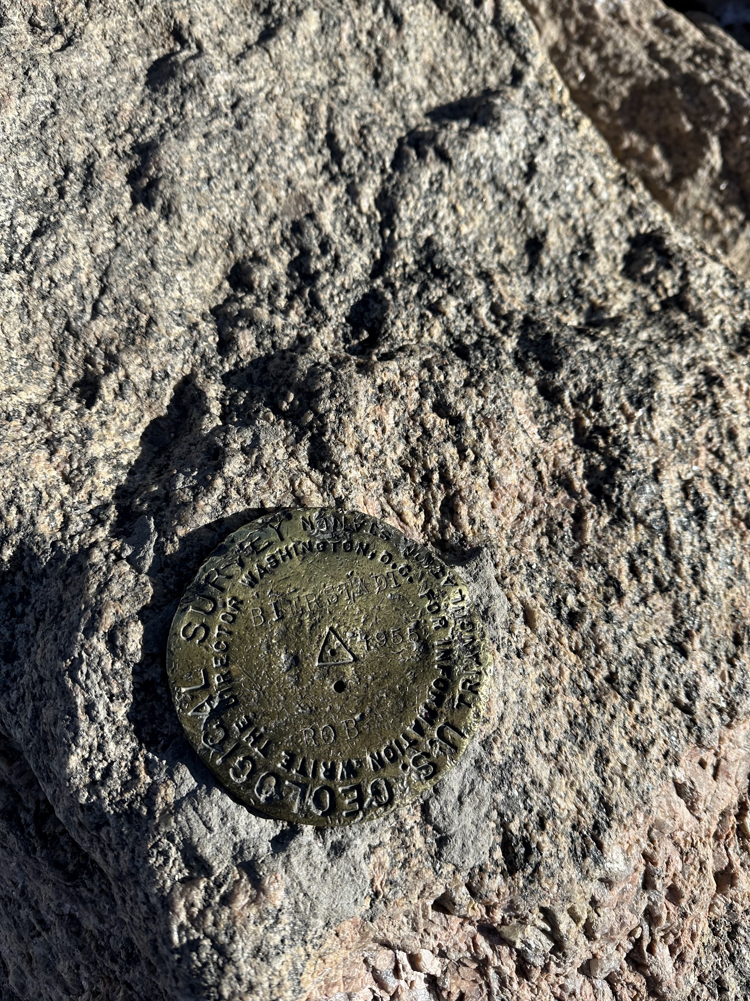
Signing the summit register

We would follow the South Ridge route to the summit. We crossed the col in about 45 minutes and were soon at the beginning of what would be the best part of the route.  The scrambling was exciting and exposed, but all the rock was solid. Laura and I enjoyed the 4th class route and were standing on the summit of Music Mountain at 11:45 am. We descended the west ridge directly back to the lake and picked up our original trail back to Music Pass and eventually the trailhead at 2:15 pm. 

Fun scrambling on the south ridge of Music Mountain

More scrambling on the south ridge

Looking back at Tijeras Peak where we had just come from

Laura on the ridge between Tijeras and Music Mountain

Justin and Laura on the summit of Music Mountain

T for Tijeras

Justin on the south ridge of Music Mountain

More fun scrambling on the ridge

Justin headed up the crux of the traverse

Having fun in the mountains

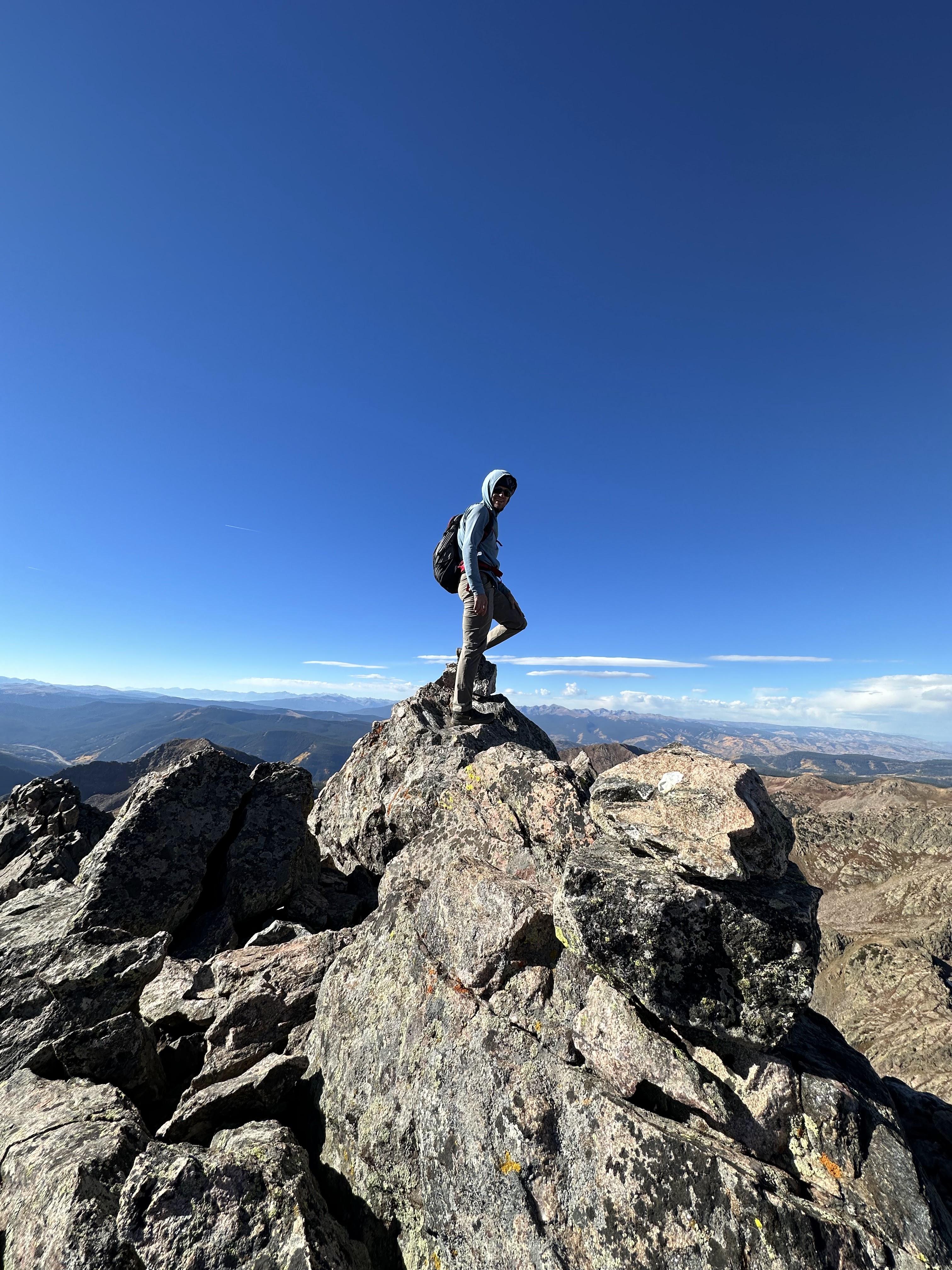
Justin trying to decide where the highest point is

M for Music Mountain


Bierstadt, Sawtooth, West Evans, Blue Sky, Spaulding

October 14, 2023

Mount Bierstadt 14,066'

Mount Blue Sky 14,268'

Winter conditions are starting to set in in the high country here in Colorado so before things got too snowy, Laura and I thought we'd take advantage of the good, low wind forecast. We agreed that we would do a very popular route that I had never done before and hike to the newly renamed Mt. Blue Sky. From the summit of Guanella Pass, we hiked quickly up the Mt. Bierstadt trail, quickly finding a well beaten path in the few inches of snow on the trail. Bierstadt is one of the most popular 14ers to hike, however today we saw only a few people along the way to the summit.

Summit of Mount Bierstadt

It took about 1:45 to summit and after taking a 10 minute break, we began our descent off the summit and across the Sawtooth. It was a bit more snowy along the traverse with 6 inches of snow in most areas, but the going was still easy and the scrambling fun. 

Justin starting across the traverse from Mount Bierstadt

Laura and I summitted the sawtooth and then began the hike toward Mt. Blue Sky. Along the way we went up and over several points, one of which was sure to be West (Evans) Blue Sky. 

Laura on one of the many high points between the Sawtooth and Mount Blue Sky

It took us 4:30 to the summit of Blue Sky and, with zero cars in the parking lot at the summit, we were lucky to have the summit to ourselves. Wanting to add on Mt. Spaulding, a high but unranked centennial peak, we made the short detour over to the 13,842' summit before heading down the gulley and into the maze of willows blocking easy access back to the parking lot. Laura had read about a better way around the willows that worked up and around a small hillside and back to the Bierstadt trail so we decided that rather than walking through the frozen swamp and willow bashing for several hours we would try that. 

Route-finding our way back with the Sawtooth traverse in the background

Turns out is it probably not any easier or faster, but it did keep our feet drier and made for an interesting descent back to the car. We finished our round trip in just under 8 hours and were pleased to have had another great day in the Colorado Mountains. 

Geological survey marker on the summit of Bierstadt

Justin on the Sawtooth traverse from Bierstadt

Justin on the ridge between Mount Bierstadt and the Sawtooth

Justin with Mount Bierstadt and most of the traverse in the background

Laura putting her gloves on for the final push up to the Sawtooth at the end of the traverse from Bierstadt

Justin at the summit of the Sawtooth

Justin and Laura on the summit of Mount Blue Sky

No tourists on the top of Mount Blue Sky today


Partner's Traverse

September 30, 2023
West Partner Peak 13,041' to East Partner Peak 13,057 Traverse

Autumn colors are popping here in Colorado right now and Laura and I were hoping to get out on a hike to see the leaves and add in some adventure to go along with the color. I had suggested something in the Indian Peaks but with a predicted late start, we knew parking there would be an issue. We opted for a trip over to the Gore range near vail. With a 3 am start from home, we were on schedule to be hiking by 6 or so. Discussing options in the car, we decided that we would park at the East Portal trailhead and hike up the frontage road to Booth Creek trailhead. From there we would climb the south ridge of West Partner Peak and then traverse to East Partner Peak. From the trailhead the path is steep. We ascended several thousand feet along Booth Creek and as the sun lit the sky, I took the opportunity to snap a few photos of the fall foliage. 

Amazing colors and views

Beautiful fall foliage

2 hours in and we were at a decision point. Our friend had ascended the west ridge a week prior but we opted to cut off the good trail and get on the south ridge, taking that all the way directly to the summit. It took us exactly 4 hours to summit East Partner Peak via the south ridge which is a very enjoyable scramble. 

Justin working up to the South Ridge on West Partner Peak

Justin on the summit of West Partner Peak
Justin and Laura on the summit of West Partner Peak looking toward the traverse to East Partner Peak

After a snack and taking in the views for 15 minutes, we began our descent and accessed the connecting ridge between the two peaks. Steady 3rd and 4th class downclimbing lead us to the ridge crest that we followed as best we could for the first half of the traverse. We soon reached a gendarme that blocked easy passage along the ridge, so we descended and traversed several hundred feet below the ridge before choosing a low fifth class gulley to regain the ridge. Back on the ridgeline, we were able to continue mostly ridge proper and scrambled our way to the summit of East Partner Peak about 2 hours after leaving the previous summit. 

Laura on a cool section of the traverse

Justin finding his way down to pass a difficult gendarme

Justin on an exposed part of the travers

The views of the surrounding Gore range are spectacular from here. We spent a few minutes looking around and thinking about the other fun climbs we had done in the area. Soon we were descending a loose gulley and grassy slopes down toward Pitkin Lake and the trail back to the trailhead where our car was parked. As we descended, I once again took the time to take in the beautiful yellows and golds of the surrounding aspen trees and colorful tundra. We reached the car 9:17 after beginning. 13.9 miles and 5,900' of elevation gain.  


Fall colors along the route

Justin hiking on the Booth Creek Trail

Laura finding the way back up to the ridge proper

Justin navigating one of the more tricky sections of the traverse

Justin hiking down through the colorful trees

Laura at the trailhead at dawn

Eureka Mountain

April 21, 2024 Eureka Mountain 13,505' Eureka Couloir Hoping to get some spring skiing in before the snow went away completely, I sugges...

Popular Posts