Flatirons Scrambles


First and Third Flatirons
December 16, 2017
Boulder, CO

Laura climbed the third flatiron with her father and uncle when she was just a kid, maybe 7 years old or so as she recalls. She says she didn't scream when they lowered her from the upper rappel bolts but I bet her dad tells the story a bit differently.


For the last month I have been resting and working on healing a nagging foot injury, so I had been climbing in flip flops rather than actual climbing shoes. Comfortable up to about 5.8 or so without shoes, I knew that Laura could get some good practice leading on easier terrain so that's what we've been working on.


We have been back from Patagonia for almost a month now. I am becoming restless and Laura keeps taking about needing to get into the mountains again. I felt like it was time to give actual climbing shoes a go so we decided to try out a few classic rock climbs on Boulders famous flatirons. Short approaches and climbable in flip flops if need be, these would be a nice way to get out again.


We opted to test my foot on the easier third flatiron - the one Laura climbed when she was just a kid. It was a chilly day so the usually crowded route had only one party in front of us. They climbed the first pitch as we geared up. Laura took off while I was lacing up my tennis shoes, still unsure about trying climbing shoes. We simu-climbed past the group in short order and lead in two blocks to the summit of the iconic rock formation. Almost like going back 30 years, Laura told stories about her father climbing in the Boulder area often. We were excited to go do more routes that he climbed and still talks about.

It was 1 pm and we still wanted to climb the slabby and run-out 10 pitch classic line on the first flatiron. Over we headed and Laura began the climb as hikers watched on. It had snowed just a few days prior, so the rock was running water in areas making the climbing quite difficult. Laura slipped on the upper portion of the first pitch and got a gasp out of the tourists. Luckily, her foot caught before taking an actual fall! We swapped leads and stretched out the entire 70 meter rope each time, occasionally needing just a few feet of simu-climbing to reach a solid belay spot which are quite difficult to find on this particular route. Making the route in 6 rather than 10 pitches, we reached the summit of the flatiron within just a few hours. We rappelled to solid ground and hiked out as daylight slowly faded, slipping and sliding down the now icy path back to the car.


Patagonia


Patagonia, Chile
Torres del Paine National Park
November 17 - 26, 2017


Summertime in South America. The shoulder season is around Thanksgiving so Laura and I knew we were a few weeks early but since our schedules worked out, we made the 30 hour trip down to the Patagonian region of southern Chile. The picturesque Torres del Paine National Park is for many something only seen on calendars and in pictures. It is regularly listed as one of the top adventure travel destinations of the world. The soaring, rugged peaks with different colored rock layers are unique and it’s towers simply amazing.


Known for its ferocious winds and variable weather, Patagonia is a place many seem to skip due to unpredictable conditions. We figured that we could deal with just about anything for a week so off we went. There are two options for trekking in Torres del Paine and we chose the longer, 80 mile O circuit. Since we’d be carrying everything we would need for the week on our backs - tent, sleeping gear, clothes, and food - we went as light as possible, each packing only the clothes on our backs an extra coat and rain gear. I carried a jet boil stove to cook our meals and Laura carried just a few additional necessities like toothbrush and sunscreen for us both. Including food for the week, we got away with our packs at 25 pounds each.

Arriving at the world’s southernmost airport in Punta Arenas, Chile, we caught the bus to Puerto Natales and grabbed a bed for the evening. The next morning we discovered first-hand the extreme Patagonian weather. 50mph winds, rain, hail, sun and snow. All before noon! We had lunch and boarded our bus to the park entrance.

In December 2016, the park changed its regulations to limit the number of visitors but upon arriving, we quickly learned that there was mass confusion and really no rules were enforced. There were fewer people than in the past, just 300 per day allowed, but there was no communication between the park staff and the two different companies operating the refugio's and camp areas.
We went to our first camp and set up the tent in a small area sheltered from the ferocious winds. Day 2 we woke early and made the 12 mile out and back hike to the famous Torres.

Only partially visible due to fog and clouds, we spent an hour and headed down to pack up camp and move on to our second site which was to be the beginning of the O circuit.


The O circuit is essentially the back side of the park. Far less travelled than the W, or front side of the park, the O is more difficult, longer and exposed. We had heard varying opinions on if John Gardner pass was open, the only option if you are to complete the O. It had been snowing heavily in the mountains and the pass may not be passable. We decided to head that way and see what happened. After walking a few miles, we met a couple who had our same itinerary but were turned around by rangers due to John Gardner pass being closed because of recent snow. We made the tough decision to turn back as well and started rearranging plans.
We could still experience the front side of the park the way the vast majority of visitors do so we decided to go for that, the W trek. Booking a bus the next morning, taking a catamaran and jumping off at Paine Grande, we headed about 6 miles out to the base of gray glacier and made camp there.

The icebergs were amazing and the glacier face rising from the lake is over 100’ tall. We spent some time exploring the area and headed back to camp.

The next morning we walked from Gray to Paine Grande, stopped for lunch and then headed to the camping area at the bottom of the hike up to Britanica. They say it closes at 2 pm but we decided to start at 4 and make a run up the 5 mile trail. We are happy that this is how we chose to do this hike because we passed many people coming down and had the up trail to just ourselves and one other couple following us. Passing by mountains with huge hanging glaciers, beautiful forests and a river flowing the entire way, when we reached the final lookout it was magical. Not another person in sight and no yelling or crazy tourists, just us and the mountains. They were completely surrounding the area. It was like being in a bowl of peaks! This was undoubtedly the highlight of our trip! We spent time there in amazement, talked about the mountains and maybe even climbing some of them and took many pictures before heading down once again.

 
We made camp for the evening and headed on to our original starting spot the next morning. The day was beautiful, walking along lake shores, rocky coasts and through dense forests. We had intended to make another go for the Torres and took a trail cutoff, but by the time we reached the main trail again just an hour later, the weather had changed once again. Storms had started and the wind was blowing us around making hiking difficult. The Torres were in the clouds again so adjusted our plan and decided to make a run for them early the following morning before heading out of the park. We make it to camp just in time to set up and beat the rain, relaxed for a bit and then visited the refugio where we sat and had a beer.
The next day we would leave the park at 1 pm so we awoke early and for the second time made the 12 mile run up to the base of the Torres. The sun was shining and it was a fantastic morning. We had seen the final viewpoint of the W trek and were happy that we made the effort to go up the difficult steep, loose and rocky trail again. Our friends Mandy and Zach were here just a few years ago so we copied their goofy pictures with some of our own and then made a beeline for the bottom.
Our first hostel when we had arrived to Puerto Natales was owned by a guy from Oregon who had moved here a decade ago and never left. He had family and friends here and celebrated a traditional Thanksgiving with everyone. Since it was Thanksgiving Day, they prepared a feast at their restaurant called Base Camp and invited anyone who wanted to join. The cost? Just donations - this was for family and about being together on Thanksgiving. Laura and I were definitely thankful for Bill and everyone who had brought home cooked meals. Turkey, potatoes, green beans, fruit salad, dressing, corn, bread and many desserts, nobody left hungry. It was nice to celebrate the holiday with our new friends and made the evening a memorable one for sure.
We retired to bed with plans for our final day in Chile. The next morning, after some insistent battling by Laura, got 2 seats on an early bus to Punta Arenas with the plan to take a ferry to see whales and penguins. Once again plans would change due to weather when the tour to Magdalena Island was cancelled so we chose to explore the city and go to a Celtic rock concert we learned about because the band was staying at the same place as us and jamming in the lobby a few hours before the show.
Patagonia is a very interesting area of the world. It is a special place and a true gem for outdoor enthusiasts. We are happy that we chose to battle the unpredictable weather and make the trip down south. Thanksgiving was extra special and really reinforced the true meaning of sharing and family. We are certainly thankful for the opportunity to be able to travel and explore this amazing world and look forward to seeing the far south end of world sometime in the future.

Climbing Devils Tower


Devils Tower

Durrance Route

October 28, 2017 


Laura and I had talked about heading for Devils Tower to climb in June, but with voluntary climbing closures all month long, we never made the trip. With a seemingly never ending list of things going on and no 3-day weekends available, we decided that the weather looked decent enough for a quick weekend trip north.
Friday after work we loaded up Big Momma, 3 dogs and gear and headed for Wyoming.
With overnight temps in the 20's, we took our time getting going Saturday morning. The route we would climb faces south, so we hoped that the sun would warm the rock and shine on us throughout the day.

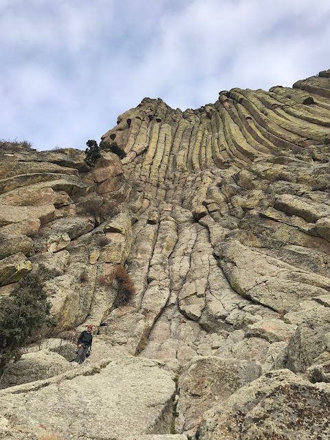
Looking up from the base of the route
The Durrance route on Devils Tower is listed as one of the 50 classics and since neither Laura or I had climbed the tower before, we agreed that despite its relatively easy rating of 5.7, this is the route we would do.
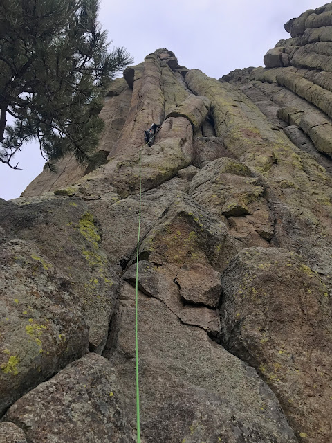
Justin leading the "leaning column"

The route is broken up into many short pitches but we combined them into just 4. The first two are off width and are like going to war with a rock. The unfamiliar climbing technique makes the route awkward but is still very enjoyable. The third is a combination of small finger jams and good footwork that eventually lead to a chimney and finally a 15 foot traversing pitch across a gap in the rock. 
From a distance, we look tiny.  We're just above the leaning column.
Pitch 2; Mom said it looked like we were hugging one of the columns for most of this pitch.

Pitch 3


Getting close!  Justin is just below center.


We summitted at a leisurly 3.5 hours from the approach hike and spent a few minutes on the top of the tower relaxing and signing the summit register. The descent is comprised of 4 twin rope rappels, each about 40 meters, and takes about a hour assuming none of the cracks eat your rope.


On the way out, hiking along with all our gear, everyone wants to know "If we went to the top" and "How long it took". The tourists all seem amazed, but we spend the time chatting and informing them of how we climb and of different routes and techniques of attaching the rope to the wall and ourselves as we climb. 


Since we'd made the long trip north, we decided that we'd make the best of out time and headed for South Dakota. Passing Crazy Horse, I told Laura a story of when my brother and I were last there about 10 years ago and had talked about coming back when we were 80 to see the progress. No notable changes have occurred in the first 10, so I'll look forward to seeing it again in another 10.

We drove over to Mt Rushmore and while we arrived just past sunset, we were happy to learn that the rock face was lit each evening until 9 pm. As darkness fell, the details of the President's faces became more defined. It was a very cool experience seeing this special monument at night; all of us had seen it in the daylight in the past.


We retired for the night in Rapid City and awoke the next morning, driving south to a national park neither Laura or I had visited before. America's 7th named national park, Wind Cave is a 100 mile maze of caves in just 1 square mile. Unfortunately for us, the cave tours were closed for the day and we had to resort to watching a short video and exploring the visitors center. We walked about 4 miles on some trails in the national park and saw buffalo, deer, coyotes, prairie dogs, hawks and wild turkey.
There is only so much you can fit into one weekend so we headed back south and discussed our next weekend adventure while driving home.


Cameron Cone

Cameron Cone just left of center
We see it every day. It sits prominently in front of Pikes Peak when viewed from our home. Cameron Cone is a 10,707' peak Just west of Colorado Springs. After attempting the peak and turning around due to snow this spring, Laura and I decided to give the "Harder than it looks" peak a second try. Somewhere around 10 miles and 4,500' of elevation gain would be our numbers for the day.

Saturday morning, we made it to Manitou Springs at 8:45 and snagged a spot in the free parking area just west of the roundabout. We began walking with an intended car to car time of 6-7 hours. We had read a few trip reports about the length and difficulty of climbing the scree fields and other parties taking 8-10 hours. We know we move pretty quickly so we weren't too concerned about being out all day. Besides, long hours on our feet would be good for us as we will be putting on 20+ mile days in just a few weeks in Patagonia.

After walking up Ruxton Ave and past the Cog train station, the road dead ends at a gate. We bypassed the gate and took the left split, following a dirt road across a bridge and up a slope ending at the train tracks. Walking up just 2 posts, we found the faint trail near the post marked 044954.

The trail climbs steeply and through many switchbacks for a mile or so, eventually reaching Magog rock. With some easy scrambling, we moved around Magog and headed up the ridge toward Gog rock. We turned around here in the spring due to snow, so the remainder of the hike was all new to us.


Gog Rock

Magog Rock


When we reached the saddle, we took a look at the map and made the decision to move further south and up gentler slopes, adding some mileage but making the final 1,500' of elevation gain easier than going straight up a very loose scree field. We encountered the large rock band just before the summit, skirted around and climbed to the top at 11:30 am, just 2:45 after leaving the car.

Looking at Gog rock and the summit from Magaog rock

The views from the summit are amazing. Looking south you get all of the Cheyenne Mountain and Colorado Springs area and to the west you have unobstructed views of Pikes Peak. Laura and I had lunch and a beer while looking at Pikes and picking out where the Barr Trail follows the mountain. After 45 minutes of relaxing, we took off for the car. Laura says it's easier on the knees to jog down the steep scree. While I agree, I prefer to speed walk while she runs. We moved quickly down to the saddle, past Gog and Magog rocks and on to the lower portions of the trail. With a combination of walking and running, we reached the car just a few hours after leaving the summit.

If you're looking for a fun, adventurous and difficult day trip, I highly suggest this peak. It's one I am happy to have checked off the list and one I won't soon forget. 10.5 miles, 4.5 hours.


Eureka Mountain

April 21, 2024 Eureka Mountain 13,505' Eureka Couloir Hoping to get some spring skiing in before the snow went away completely, I sugges...

Popular Posts